Find Us Here!
We are part of the Wood Street ward of the London Borough of Waltham Forest. Wood Street is part of Walthamstow, E17.
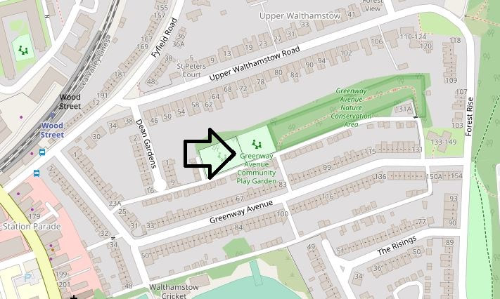
We are located behind the odd numbered side of Greenway Avenue. Greenway Avenue itself runs off Upper Walthamstow Road. This itself branches off Wood Street, the main shopping road of the ward. The Overground station is at the junction of Wood Street and Upper Walthamstow Road.
Note that the access road indicated behind behind Greenway Avenue on the community garden side is mainly a dirt track. It has 3 entrances. One each at the top and bottom of Greenway Avenue – the third is about half way up the hill and you can see the garden gate from the road. This one is mostly sealed - not perfectly - but probably offers better access for those with mobility issues.
WALKING OR CYCLING:
If you would like to visit the garden we are located as shown by the arrow in the map above. For an interactive map you can either click on the map image itself or visit the link below:
Openstreetmap
What3Words
You can also locate is via this website: what3words.com/
What3words is a fast and simple interface that allows you to convert 3 word addresses to coordinates and vice versa.
///reply.posts.chair
will get you pretty close to the main access gate for the garden. Pick the option "near Walthamstow" offered.
CLOSEST CONNECTIONS:
NATIONAL RAIL:
The nearest station is Wood Street overground station as shown on the map. It is on the Chingford to Liverpool Street line and one stop from Walthamstow Central (Victoria Line) if you change there for the overground.
The garden is about a 5-10 minute walk from Wood Street station and the 230 bus stop. As you leave the station, left then first right into Greenway Avenue...easy. Walk about a hundred yards and turn left up the track...we're up there...
LONDON UNDERGROUND:
Victoria Line - Walthamstow Central
As indicated above, pick up the Overground line at the top of the escalators and stairs to Wood Street station.
Central Line - Snaresbrook
If you don't mind a 25 minute walk, the garden can also be accessed from the Central line at Snaresbrook station.
Down the ramp and right at the lights around the corner and as you approach the Eagle pub turn left onto Snaresbrook Road. Continue past the lovely Eagle Pond, navigate the traffic lights directly over the A104 (Woodford New Road), continue up the hill along Forest Rise and left down Greenway Avenue.
If you wish, take a right at the first track that leads off the dogleg and perhaps take a stroll through the Conservation area.
Alternatively, walk further down the road about half way to the dogleg and right onto that short track that will get you straight there.
DIRECT BUS SERVICES:
Bus Route 230:
The 230 bus route services Wood Street station, which is the closest stop to the garden. Follow the guidance above from there.
https://tfl.gov.uk/bus/route/230/
Central Line Bus Connection from Snaresbrook (W12)
If you are patient you can walk around the corner from the station along past the Eagle pub to the Eagle Lane bus stop, you can pick up the W12 that will take you along Snaresbrook Road. It will take you around the corner to Hainault Court, but if you make your way back you can pick up the walking route at the traffic lights you just left. Follow the walking guidance from there.
https://tfl.gov.uk/bus/route/w12/
